AI and Geospatial Intelligence Transform Public Reporting in Westminster City Council
Geospatial AI, or GeoAI, combines artificial intelligence with location-based data and geographic information systems to analyze and interpret spatial information intelligently and at scale.
 Westminster City Council, serving a densely populated urban area, faced significant challenges with its outdated public reporting system for issues like waste management and street cleanliness.
The legacy process suffered from inconsistent location data, manual handling delays, and inaccuracies, leading to inefficient service delivery.
To address this, the council developed Report It, a cloud-based platform leveraging AI and geospatial intelligence. Key features include:
- Integration of Google Maps API, advanced geocoding, and Unique Street Reference Numbers (USRN) for precise issue location mapping and optimized routing.
- AI-powered tools for image classification (e.g., categorizing photos of reported problems) and a chatbot for guiding user inputs, ensuring accurate submissions.
The project involved collaboration across internal teams (digital, GIS, waste services, IT) and external partners, following a five-stage design process with resident surveys, interviews, and observational research to refine the user experience.
Outcomes and Benefits
- Efficiency Gains: Submission accuracy rose to 86% (from previous lower levels), with average reporting time dropping from 5 minutes to just 88 seconds. Response times improved, site visits decreased, and manual processes were fully eliminated.
- Broader Impact: Enhanced cross-departmental data sharing has extended the platform to services like streetlighting, highways maintenance, and anti-social behavior reporting, fostering better collaboration and resource allocation.
- Citizen Engagement: Increased trust and participation in reporting, with residents appreciating the intuitive, mobile-friendly interface.
The initiative has sparked interest from other UK authorities, positioning it as a model for national replication. Looking ahead, Westminster plans to expand Report It to more service areas, emphasizing smarter data use for proactive issue resolution and improved public outcomes.
 Geospatial AI
Geospatial AI, or GeoAI, combines artificial intelligence with location-based data and geographic information systems to analyze and interpret spatial information intelligently and at scale. It processes diverse inputs such as satellite imagery, GPS tracks, addresses, and sensor data from IoT devices.
By applying machine learning techniques like computer vision, natural language processing, and predictive modeling, GeoAI can detect objects in images, understand place references in text, forecast risks such as floods or traffic, and automate decision-making.
At its core, the technology ingests vast datasets, runs advanced algorithms to extract patterns, and integrates results with GIS tools to produce maps, optimized routes, or real-time alerts. In practice, it powers applications from urban issue reporting—where it classifies photos and pinpoints problems accurately—to disaster response, precision agriculture, and environmental monitoring.
The benefits include faster processing, higher accuracy, proactive issue detection, and significant cost savings through efficient resource use. However, challenges remain, including data quality, privacy concerns, and integration with legacy systems.
Looking ahead, GeoAI will drive autonomous navigation, climate resilience, and interactive digital twins of cities, transforming how societies understand and manage the physical world. In essence, it is AI that truly comprehends *where* events occur, turning location into actionable insight.
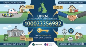
Unique Street Reference Numbers (USRNs) are standardized, nationally unique identifiers assigned to every street, road, or thoroughfare in Great Britain. Maintained within the National Street Gazetteer (NSG)—a centralized database managed by local highway authorities and coordinated by GeoPlace—they provide a consistent way to reference and locate streets across different systems, organizations, and datasets.
Each USRN is an eight-digit numeric code (e.g., 84012567) linked to detailed metadata, including the street’s official name, geographic coordinates, administrative boundaries, and maintenance responsibility. Unlike postal addresses or descriptive names, which can vary or be duplicated, a USRN unambiguously identifies a specific stretch of road, even when names change or multiple authorities share jurisdiction.
Relation to Geospatial AI
In Westminster City Council’s Report It platform, USRNs play a critical role in accurate geocoding and routing.
When a resident reports an issue like illegal dumping, the system uses AI and mapping tools to convert vague inputs (“near the park on Victoria Street”) into precise coordinates. It then matches these to the correct USRN, ensuring the report is attached to the exact street segment.
This enables:
- Automated crew dispatch to the right location.
- Integration with council asset systems (e.g., waste, lighting, highways).
- Data consistency across departments and external contractors.
By anchoring reports to USRNs, GeoAI eliminates location ambiguity, reduces failed site visits, and accelerates response—transforming public reporting from error-prone to highly reliable.
In short: USRNs are the authoritative “DNA” of Britain’s streets, giving Geospatial AI a trusted spatial backbone for intelligent, location-aware decision-making.


